Aug. |
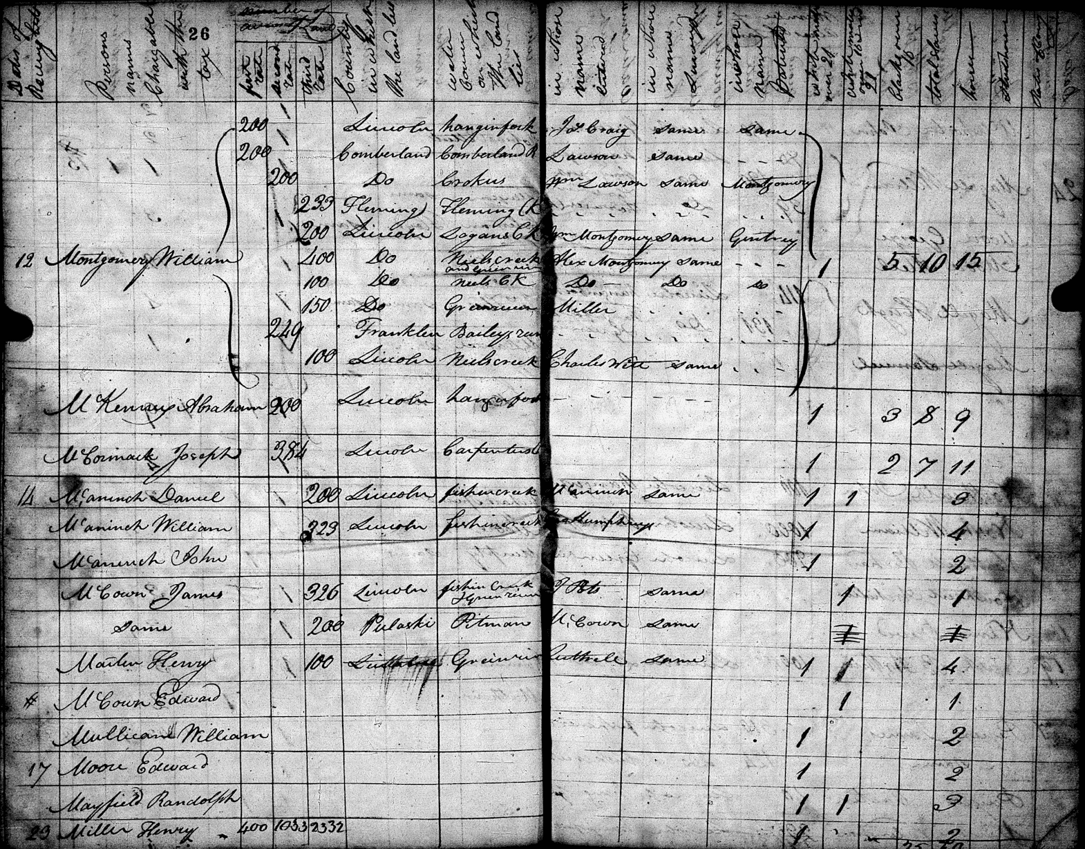
Daniel (200a 3r, Fishing Cr), John (no land), William (323a 3r, Fishing Creek, Lincoln) - |
1805 |
Aug. 14, 1805: Daniel, William, and John McAninch are sequential entries on three lines |
|
of the same page on the Lincoln County Tax List in 1805 - |
|
Daniel McAninch, 1 White Male 21 and over, 1 White Male 16-20 (his son Samuel), |
|
3 Horses, 200 acres of 3rd‑rate land in Fishing Creek watershed, Entered by "McAninch", |
|
Surveyed by "same" and the Patented column is blank. [Sam] [CBL.n] [1805 3McA] |
|
William McAninch, 1 White Male 21 and over, 4 Horses, and 323 acres of 3rd‑rate land |
|
in the Fishing Creek watercourse / watershed, Entered by "Geo Humphrey" (sic), both of |
|
the Surveyed and Patented columns are blank. [CBL.n] [1805 3McA] |
|
John McAninch (no land), 1 White Male 21 and over, 2 Horses. [CBL.n] [1805 3McA] |
|
|
1805 |
Note: This is the last record of John McAninch (son of Daniel McAninch) in the land |
|
ownership and tax records of Lincoln County, Kentucky; John and his wife Patsy (Cooper) |
|
McAninch will be going south to new lands opening up in Giles County, Tennessee. [Jhn] |
|
|
Aug. |
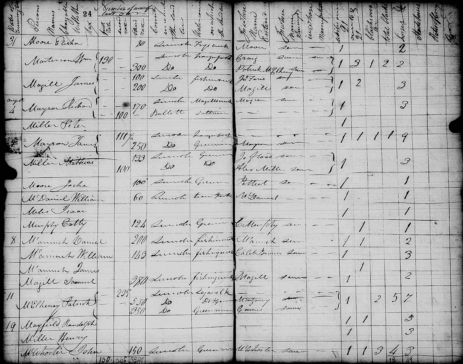
Daniel (200a 3r, Fishing Cr), James (no land), William (143a 3r, Fishing Creek, Lincoln) - |
1806 |
Aug. 8, 1806: Daniel and William McAninch, and James McAninch (son of William) are |
|
sequential entries on three lines of the same page on the Lincoln County 1806 Tax List - |
|
Daniel McAninch, 1 White Male 21 and over, 1 White Male 16-20 (his son Samuel), |
|
2 Horses, and 200 acres of 3rd‑rate land in Fishing Creek watershed, Entered by Daniel |
|
McAninch, Surveyed "same", and Patented column blank. [Sam] [CBL.p] [1806 3McA] |
|
William McAninch, 1 White Male 21 and over, 3 Horses, and 143 acres of 3rd‑rate land |
|
in the Fishing Creek watercourse / watershed, Entered by Caleb Brown, Surveyed by |
|
"same" (sic), and the Patented column is blank. [CBL.p] [1806 3McA] |
|
James McAninch (no land), 1 White Male 16-20, no Horses. [CBL.p] [1806 3McA] |
|
|
Nov. |
Casey County defined Nov. 14, 1806, to start May 4, 1807 - "Act of the General Assembly, |
1806 |
November 14, 1806, that from the first Monday in May next (Monday, May 4, 1807) . . . |
|
part of Lincoln County . . . (land description) . . . shall form . . . Casey (county)" [Casy] |
|
Note that Casey County Commissioners’ Books and Tax Records do not start until 1808. |
|
|
June |
William (286a ?r, Rock Lick Creek a branch of Fishing Creek, Pulaski) |
1807 |
(". . . on the waters of the Rock Lick Creek a branch of Fishing Creek") - |
|
William McAninch, assignee of Caleb Brown, survey listed for 286 acres |
|
(see 1802 above), part of 400 acres Brown had by . . . Pulaski County Court Certificate |
|
No. 406 . . . by survey . . . the 29th day of June 1807 . . . lying and being in the County of |
|
Pulaski on the waters of the Rock Lick Creek a branch of Fishing Creek" |
|
(Note: Rock Lick Creek, not ‘Bucklick’ creek, that was a earlier transcription error). |
|
Survey was recorded in Pulaski County Survey Bk.1 pg.102, per Kentucky Land Grants, |
|
"Grants South of Green River", and see William (286a) land grant in 1840, land then |
|
divided and sold as two 143-acre halves in 1841. [GSG.p374] [Tlin.g] [Tlin.h] |
|
|
|
______________________________________________________________________ |
|
McAninch in Kentucky, 1797-1807, The First 10 Years |
|
McAninch Family History Newsletter, v.XXXIV (34) n.1 / August 2026 / p.2026-09 |
|
|
|
Table of Contents for this Year First Page of this Issue Previous Page Next Page |